
Synopsis:
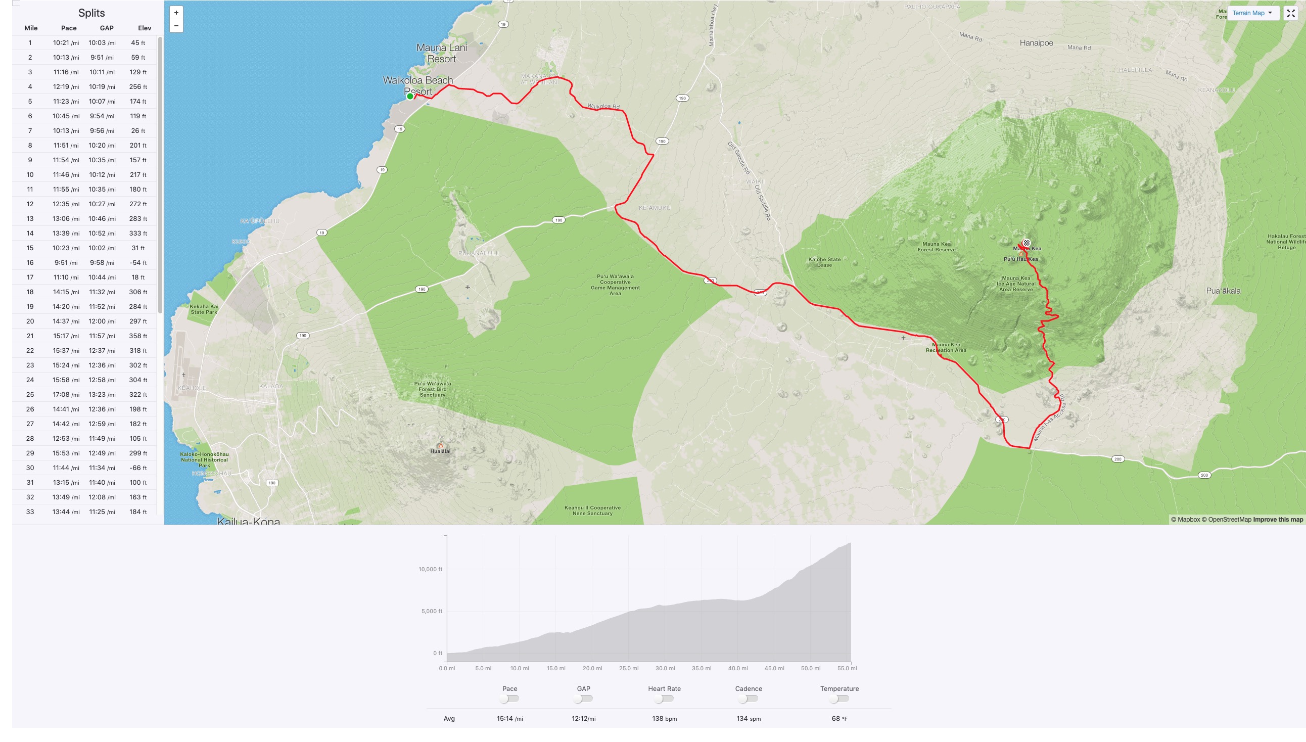
| Distance to Summit: | 55.6 miles |
| Elevation Gain: | 14,108 feet |
| Time to complete: | 17:29:28 |
| Number of Known Ascents: | 1 |
This is one of the harder ways to run up Mauna Kea. Though there is a road the whole way to 1/8 mile from the top, your greatest hurdle besides the distance and elevation will be the wind. The prevailing winds come from Hilo through the saddle and blow right down into Waikoloa (We jokingly refer to the area as Waiko-BLOW-a). So you will face a headwind from 5-35 mph for 41 miles until you reach the Mauna Kea Access Road.
What to expect:
The Serious Part:
Having been in some big scary mountain ranges in the world I would say it was pretty easy for me to underestimate this “Sub” 14,000-foot volcano on a tropical island. The first time Toby Olney and I went from the Sea to Summit of Mauna Kea we did it from Hilo. We started on our bikes on a beautiful morning downtown, rode up to the Mauna Kea Visitor Center as a weather system came slowly in. Put on our shoes and hoofed it up the trail through rain that then became snow at 11,000 feet and a sideways driving blizzard by the time we reached the summit at sunset. We had the proper gear for the conditions – but only because we had a support vehicle meeting us at the top. We would have fared badly if we would have been caught out in the dark for a few hours in those conditions while dehydrated and glycogen depleted from the ascent.
Foul weather, heavy snow, and high winds are all reasons that the summit can be closed to everyone. So pay attention to the weather forecast. Even a perfect blue sky day can have winds in excess of 75 miles an hour on the upper slopes of the mountain and the road will be closed to all people and traffic.
The Fun Part:
It really isn’t hard to prepare for this run. Just use common sense and prepare and carry for the worst but expect the best. The Lower section (0 to 4000) is typically hot in the day and perfect at night. The middle section (The Old Saddle Road Junction to the Visitor Center – 5000 to 9000) is coolish with temperatures that can be between 40° and 80° F degrees in the day. The upper section above the Visitor Center is colder and there will almost always be a wind chill factor on top of that. So below freezing to 75° F.
Expectations:
Expect a hard headwind and if you are blessed with a soft one then count your lucky stars and enjoy the day. Expect you will be sunburned if you don’t reapply sunscreen a few times. Plan for rain and freezing temperatures but expect you won’t run into those conditions. Oh and train on the pavement for this one because you are going to get around 51 miles of it.
The Route:
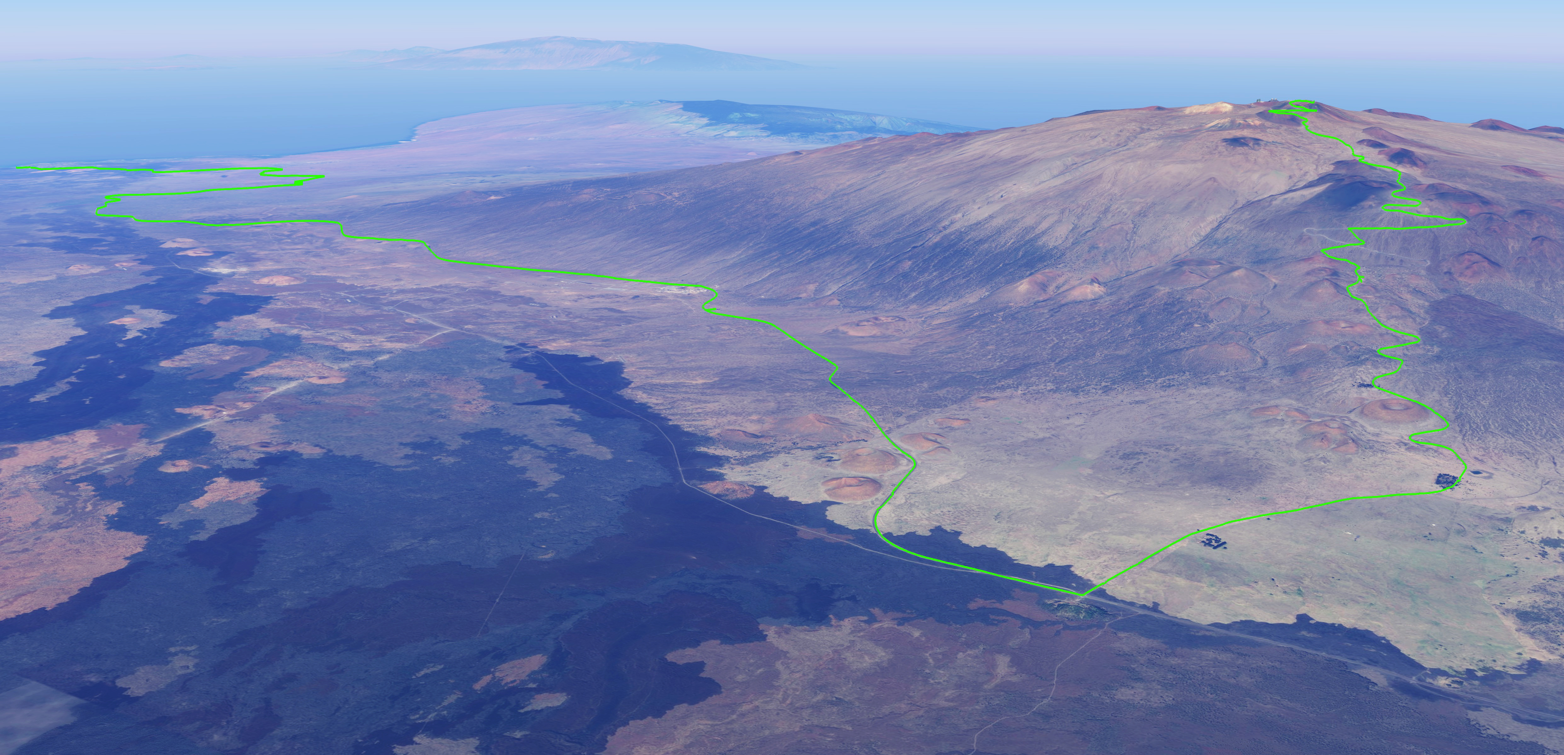
Below is a public map I created to give you the exact route to follow. There are 2 options I show in the map and a 3rd option that exists that allows for cutting around a mile off the switchbacks above the Visitors Center. You can see that option on the Strava Map. Ultimately option 2 where you take the trail up from the Visitors Center is the shortest yet it is steep and technically harder to travel. Also, you don’t get support for this whole section until the last mile.
Note on the interface below: if you click/tap on the full-screen icon in top right corner it will open the map in a new tab or Google Maps for you.
Where to Start:
‘Anaeho’omalu Bay (A-Bay) is one of the best places to start a Sea to Summit on the island. The spacious parking lot is open 24 hours a day and it is a 2-minute walk to a perfect sandy beach start.
When to Start:
Time Of Day:
This, of course, depends on how fast you are. But as mentioned earlier, plan on the lower section to be very hot in the day and the upper sections to be very cold in the dark. Also once the sun comes up the wind typically picks up down in Waikoloa which encourages a predawn start. We chose a midnight start which gave us a nice cool start. We managed to reach 24 miles and the 5000-foot area at around 5:30 am as the sun was coming up. The sun glows on the Horizon of the saddle around 25 minutes before official sunrise. The temperatures at this point were around 40 degrees Fahrenheit (not including wind chill factor). This is cold but as a bigger runner, I liked it much more that way. On a training run where we started at 6:00 am I hit this point at 11:30 am where it was 80 degrees, minimal wind, and I was heavily dehydrated since we were self-supported.
One other important point in considering a very early start: You can be kicked off of the top of the mountain right after sunset. If the park service sees you after dark they may try to stop you. If you have a support vehicle (which you better have if you are flirting with the dark) they may try to boot them off the top of the mountain as well.
Time of Year:
Of course, to give yourself the best chance of success you will likely want the longer days of summer. Though it can snow in summer it doesn’t do it as much as winter. We went after it on a full moon on April 20, 2019, and the day felt just long enough.
What to bring:
If you are reading this you know the main ultra gear you need to bring. Plan for rain, cold wind, and sub-freezing temps. If you bring it you likely won’t need it. If you don’t… you know how that goes. If you have the luxury of a support vehicle, know that it will need to go into an area that says 4 wheel drives only. A Toyota Prius could drive up this section and I’ve seen many a rental car up there. So basically any vehicle can make it up to the top. Just know you will strain that vehicle a bit pushing it up the steep roads in the thin air and the few miles of washboard dirt roads it will need to travel. But… if there is foul weather or snow up there your vehicle must be a 4 wheel drive.
Supported, Self-Supported or Unsupported:
We found a combination of supported and self-supported was the way to do this. With a midnight start, our water needs were lower so we stashed a cache 17.5 miles into the run a 1/2 mile up the Inouye Hwy. We then had our first support meet us at 6:30 am (around 30 miles in) and had a support vehicle for the rest of the day. This way you don’t wear down a support person who needs to be with you the whole way. This could be all self-supported if you set caches where I mention above and at the Old Saddle road junction (26.6 miles in) and the Visitors Center (47 miles in). There is water at both the Mauna Kea Recreation area (34 miles in) and the Mauna Kea Visitor Center but really nowhere else of value on this route.
As to Unsupported: It would be a proud ascent but you are going to need to be a camel since you can’t stash caches. But if you can make 34 miles and 6700 feet of elevation gain on one supply of water then you have made it to the water at the Recreation Area and you are golden because the Visitor Center is only 13 miles away for your next fill up.
Any way you do this you really need someone to meet you at the top. You do not want to walk/run the 8.7 miles and 4800 feet back down to the Visitor Center. But hey… Maybe you are looking for a bigger challenge – good on ya then.
What I expect in the future:
Obviously, my FKT will not last long if someone with any real talent shows up to do the route. But oddly I think more people are going to want to do the Hilo route because it is shorter and friendlier in general. And of course, more people are going to want to have a higher probability of tagging the top if they only have one chance when they come here. So I think this route might not see a whole lot of action from visitors. But someone will show up and want to go the hard way and do this self-supported and faster. And it will be exciting to see.
Suggested Links:
Related posts
-
-

Hamakua Challenge Training – Pololu to Honopue – Out and Back
August 20, 2019
-

Hamakua Challenge Training – Waipi’o to Waimanu – Out And Back
August 19, 2019
Leave a reply